

Ayutthaya Temple Map: How to Navigate the Historical Park (2026)
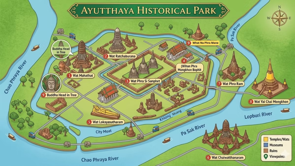
Ayutthaya Historical Park sits on an island formed by the Chao Phraya, Pa Sak, and Lopburi rivers. The major temples are clustered in the central and western sections of the island, within cycling distance of each other. A free printed map is available from the Tourism Authority of Thailand office near the park entrance. Google Maps works well for navigation within the park. The most efficient single-day route starts at Wat Mahathat, moves west through Wat Phra Si Sanphet and Wat Lokaya Sutha, then crosses to Wat Yai Chai Mongkhon before finishing at Wat Chaiwatthanaram on the riverside.
Understanding where the temples are in relation to each other before you arrive transforms how efficiently you visit Ayutthaya Historical Park. The island is compact but the sites are spread across it — and a few key temples sit just outside the island boundaries, requiring a short crossing or ride. This guide covers the geography, the best route, and where to find the official map.
Understanding Ayutthaya’s Geography
Ayutthaya Historical Park occupies an island roughly 8 km long and 4 km wide, formed by the confluence of the Chao Phraya River (west and south), the Pa Sak River (east), and the Lopburi River (north). The major temples are concentrated in the central and western sections. Several important temples — including Wat Chaiwatthanaram, Wat Yai Chai Mongkhon, and Wat Phanan Choeng — sit just outside the island’s boundaries and require a short tuk-tuk or bicycle ride across a bridge or river.
The ancient city of Ayutthaya was deliberately built on an island — the rivers provided natural defensive barriers and trade access simultaneously. Today the island contains the bulk of the Historical Park, while several significant temples are located in the immediate surrounding areas.
The island’s key areas:
Central island (around Naresuan Road): The highest density of temples and the most visited area. Wat Mahathat, Wat Ratchaburana, Wat Phra Ram, Wat Phra Si Sanphet, Wiharn Phra Mongkhon Bophit, and Wat Lokaya Sutha are all in this central zone. Most are within a 10–15 minute walk or 5-minute cycle of each other.
Western bank (Chao Phraya River): Wat Chaiwatthanaram sits on the western bank outside the central island, accessible by a road bridge or by boat. This is Ayutthaya’s most photogenic riverside temple and requires a deliberate 2–3 km ride from the central zone.
East and southeast: Wat Yai Chai Mongkhon is located southeast of the train station, outside the main island. Wat Phanan Choeng is on the south bank. Both require a tuk-tuk or bicycle crossing.
North: Wat Phu Khao Thong (Golden Mount) and Wat Na Phra Mane are north of the island, across the Lopburi River, reachable by road bridge.
Temple Locations at a Glance
| Temple | Zone | From Wat Mahathat |
|---|---|---|
| Wat Mahathat | Central island | Starting point |
| Wat Ratchaburana | Central island | 2-min walk |
| Wat Phra Ram | Central island | 5-min walk |
| Wat Phra Si Sanphet | Central island | 8-min walk or cycle |
| Wiharn Phra Mongkhon Bophit | Central island | Adjacent to Wat Phra Si Sanphet |
| Wat Lokaya Sutha | Central island | 10-min cycle |
| Wat Chaiwatthanaram | West bank (off-island) | 15-min cycle or tuk-tuk |
| Wat Yai Chai Mongkhon | East of station | 15-min cycle or tuk-tuk |
| Wat Phanan Choeng | South bank (off-island) | 15-min tuk-tuk or boat |
| Wat Na Phra Mane | North (off-island) | 20-min cycle or tuk-tuk |
| Wat Phu Khao Thong | North (off-island) | 20-min cycle or tuk-tuk |
| Wat Ratchaburana | Central island | 2-min walk from Wat Mahathat |
The Official Ayutthaya Map
A free printed map of Ayutthaya Historical Park is available from the Tourism Authority of Thailand (TAT) office near the park entrance, from most hotels and guesthouses on request, and sometimes from Fine Arts Department ticket booths at major temples. Google Maps works accurately throughout Ayutthaya for navigation between temples. Maps.me (offline maps) is a useful alternative for visitors concerned about data connectivity.
Where to get it: A free printed map of Ayutthaya Historical Park is available from: – The Tourism Authority of Thailand (TAT) office, located in the former municipal building (Sala Kan Muang) near the Historical Park — an excellent first stop, as it also hosts a free exhibition on Ayutthaya’s history and a tourist information counter – Most hotels and guesthouses in Ayutthaya provide a copy on request – The Fine Arts Department booth at major temple entrances sometimes has copies
The official map marks all temples, palaces, museums, and points of interest within and around the Historical Park. It includes the suggested touring route for visitors exploring by bicycle.
Digital alternatives:
- Google Maps works accurately throughout Ayutthaya and can navigate between temple addresses. Search each temple by name with “Ayutthaya” appended (e.g. “Wat Mahathat Ayutthaya”) for reliable results.
- Maps.me (offline maps) is useful if you’re concerned about data connectivity within the park.
- The TAT and several travel sites publish downloadable PDF maps of the Historical Park.
Recommended One-Day Route
The most efficient one-day Ayutthaya temple route starts at Wat Mahathat (8:30 AM), moves to Wat Ratchaburana (adjacent, 2 min walk), then Wat Phra Si Sanphet and Wiharn Phra Mongkhon Bophit (8-min cycle west), then Wat Lokaya Sutha (10-min cycle). After lunch, tuk-tuk to Wat Yai Chai Mongkhon (15 min southeast), then finish at Wat Chaiwatthanaram (15 min west) for the late afternoon light.
For a full day visiting the major temples, this sequence minimises backtracking and visits each site in good light:
Morning (8:30 AM – 12:00 PM):
- Wat Mahathat — Start at opening (8:30 AM), buy the combo pass here. 45–60 minutes.
- Wat Ratchaburana — 2-minute walk east. 20–30 minutes.
- Wat Phra Si Sanphet + Wiharn Phra Mongkhon Bophit — 8-min cycle west. 40–50 minutes combined.
- Wat Lokaya Sutha — 10-min cycle west. 20 minutes (free, open air).
Midday break (12:00 – 1:30 PM): Lunch at a restaurant near the park. See Best Restaurants Near Ayutthaya Temple.
Afternoon (1:30 – 5:30 PM):
- Wat Yai Chai Mongkhon — 15-min cycle or tuk-tuk southeast. 30–40 minutes.
- Wat Chaiwatthanaram — 15-min cycle or tuk-tuk west (off-island). 45–60 minutes. Best visited in the afternoon when the light comes from the west.
This route covers the six most significant temples comfortably within one day, with the best light conditions for each.
Book This TourGetting Around the Map
For the central island temples, bicycle (50–80 THB/day) is the best navigation method — the island is flat and distances are manageable. For off-island temples (Wat Chaiwatthanaram, Wat Yai Chai Mongkhon, Wat Phu Khao Thong), a tuk-tuk (200 THB/hr or 500–600 THB full day) is more practical. Grab works in Ayutthaya for on-demand tuk-tuk rides without negotiation.
The most effective way to navigate Ayutthaya’s temple map is by bicycle for the central island temples and tuk-tuk for off-island temples like Wat Chaiwatthanaram and Wat Yai Chai Mongkhon. See our full Getting Around Ayutthaya Temple guide.
Key distances:
- Wat Mahathat to Wat Phra Si Sanphet: approximately 700 metres (10-min walk, 3-min cycle)
- Wat Phra Si Sanphet to Wat Chaiwatthanaram: approximately 2.5 km (15-min cycle, 10-min tuk-tuk)
- Wat Mahathat to Wat Yai Chai Mongkhon: approximately 3 km (20-min cycle, 10-min tuk-tuk)
Frequently Asked Questions
Where is Ayutthaya Historical Park on a map?
Ayutthaya Historical Park is located approximately 80 km north of Bangkok, on an island at the confluence of the Chao Phraya, Pa Sak, and Lopburi rivers. The city of Phra Nakhon Si Ayutthaya sits on the same island. GPS coordinates for the park centre: approximately 14.3500°N, 100.5600°E.
Where can I get a free Ayutthaya temple map?
From the Tourism Authority of Thailand office near the Historical Park (in the former Sala Kan Muang building), from most hotels and guesthouses, and sometimes from the Fine Arts Department ticket booths at major temples.
Which temples are on the main island?
Wat Mahathat, Wat Ratchaburana, Wat Phra Ram, Wat Phra Si Sanphet, Wiharn Phra Mongkhon Bophit, and Wat Lokaya Sutha are all on the central island. Wat Phra Mongkhon Bophit is adjacent to Wat Phra Si Sanphet.
Which temples are off the main island?
Wat Chaiwatthanaram (west bank), Wat Yai Chai Mongkhon (southeast of the station), Wat Phanan Choeng (south bank), Wat Na Phra Mane (north), and Wat Phu Khao Thong (north) are all outside the central island boundary. They require a short crossing or ride.
Can I navigate Ayutthaya using Google Maps?
Yes. Google Maps works accurately throughout Ayutthaya and can navigate between temples, restaurants, and accommodation. Search each temple by name followed by “Ayutthaya” for reliable results.
How big is Ayutthaya Historical Park?
The park covers approximately 289 hectares of the island and contains over 67 temples and ruins within its boundaries. The full island is roughly 8 km long and 4 km wide.
